Date :
Sunday, July 11, 2021
Western Polesie in Belarus is divided into regions, one of which is Zagorodie. It is located between two rivers: the Western Bug in the west and the Horyn in the east. Many people call a plain, which extends along the road from Kobrin to Pinsk, “Zagorodie”.
History and territory
In the scientific literature, the term “Zagorodie” appeared approximately in the 1650s, and back then, as it is believed, it was already quite a popular word. It referred to the area near the Pinsk district and was an antonym of the word “Zarechye” (“behind the river”). Over time, the boundaries of this territory expanded: at first, they stretched from Pina to Pripyat, and then they reached the lower reaches of the Horyn. In 1895, a book was published in Poland, which identified Zagorodie as the space among the three districts located northeast of Pina: Pinsk, Luninets and Ivanovo.
Geographical facts

- The length of the Zagorodie Plain from west to east is 85 km and 15-35 km from north to south.
- The territory of the region covers about three thousand square kilometers.
- The highest point reached on the plain is 179 meters above sea level.
- From the northern part the surface smoothly changes from uplands to hills, and to the south it becomes flat.
- The most common areas in the north of the region are swampy lowlands and hilly uplands in the southern part.
- 30% of the total area is allocated for agricultural work.
- One-fourth of the area is forested.
Tourism and its development in Polesie Zagorodie
At the moment, tourism in this area is developing as part of the whole Western Polesie. There are no specific routes, except for the one that will be discussed at a seminar held by the National Tourism Agency on July 13-14.
However, there are certain places that many tourists recommend visiting.
Chapel-tomb in Zakozel
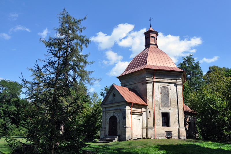
Not far from Drohiczyn there is an old Neo-Gothic building, which was built by the famous Orzeszko family in the XVIII century. The chapel is a complex structure with pointed two-slope roofs. They are covered with sheets of copper, they have phials (pinnacles), arched niches and statues of evangelists. The structure has never been restored, and as a result, it began to deteriorate, which led to the closure of the passageway inside the chapel. But even through the bars you can see this architectural marvel, next to which there is a park with ancient trees.
Kudrichi village
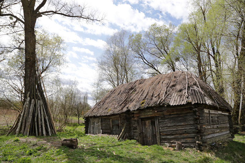
This village is now called the “Belarusian Venice”, because only 30 years ago it was surrounded by water. Just imagine, only since the 1990s, when the road was paved, Kudrichi began to be transformed into an ordinary village. There are still houses with thatched roofs, every inhabitant has a boat, and even unusual beehives made of oak logs are preserved!
Duboe village
It is at least 500 years old, and during this time it has been home to Christian saints, rich nobles and German soldiers during World War I.
In the XIX century, a palace and a chapel were built in Duboe. The chapel stands on a hill in the center of an ancient French park, recognized as a natural monument. For many years it has been under restoration, but recently the facade has been repaired, besides, it is promised that works will be carried out on the interior.
The park was founded around the XV century, but even now it looks very decent.
The south of Belarus is an amazing place, where everyone will get an aesthetic pleasure from the natural beauty, as well as be very surprised by the dialect of the Poleshuks, the locals. Their language is a mixture of Belarusian, Ukrainian and Polish, and its peculiarity is that many villages were cut off from each other, so they led an isolated way of life. A visit to Polesie Zagorodie is an interesting choice for a trip around Belarus!